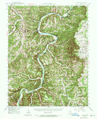
1937 Map of Vienna
USGS Topo · Published 1972About this map
The winding Gasconade River dominates this landscape, its deep meanders creating a terrain of sharp ridges and isolated bottomlands like Bloom Garden and Johnson Island. Before the modernization of rural bridge networks, the river was crossed at numerous points such as Lanes Ford, Paydown Ford, and via the Bates Ferry, reflecting a river-dependent economy in the 1930s. The presence of the Vichy Airport and the Ferrill Clay Pit near Vichy indicates the gradual shift toward industrial and aviation infrastructure at the edge of the Ozark highlands.
Find a feature on this map
59 named features on this map. Tap any name to fly to it.
Don’t see what you’re looking for? This feature index may not catch every label — zoom into the map to look around manually.
Map Details
Editions of this 1937 Vienna Map
2 editions found
Other maps of this area

1888 · Tuscumbia
USGS Topo · 1:125,000

1894 · Tuscumbia
USGS Topo · 1:125,000

1912 · Rolla
USGS Topo · 1:62,500

1928 · Meramec Spring
USGS Topo · 1:62,500

1934 · Linn
USGS Topo · 1:48,000

1934 · Bland
USGS Topo · 1:62,500

1934 · Redbird
USGS Topo · 1:62,500

1936 · Waynesville
USGS Topo · 1:48,000

1937 · Bland
USGS Topo · 1:62,500

1937 · Vienna
USGS Topo · 1:62,500