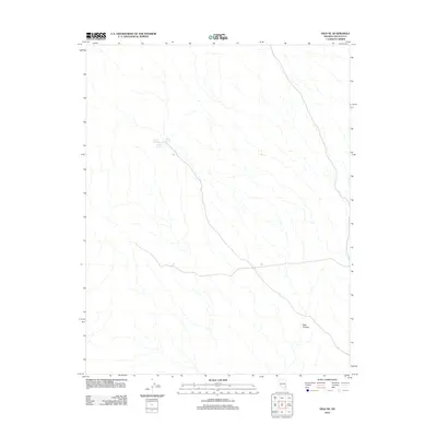
2012 Map of Vigo NE
USGS Topo · Published 2012About this map
Averett Spring and the Averett Reservoir occupy a central role in this Lincoln County landscape, serving as critical water sources in a region defined by its drainage patterns. This map illustrates the arid geography of the area, where water features like Hidden Spring are essential landmarks amidst the network of desert washes. The topography is dominated by the descent into Vigo Canyon in the southeastern portion of the sheet. The sparse road network and lack of established settlements highlight the area's isolation, focusing instead on the natural landforms and the subtle infrastructure required to manage seasonal water flow in the high desert.
Find a feature on this map
4 named features on this map. Tap any name to fly to it.
Don’t see what you’re looking for? This feature index may not catch every label — zoom into the map to look around manually.
Map Details
Editions of this 2012 Vigo NE Map
This is the sole edition of this map. No revisions or reprints were ever made.
Other maps of this area

1885 · Pioche
USGS Topo · 1:250,000

1886 · Pioche
USGS Topo · 1:250,000

1954 · Caliente
USGS Topo · 1:250,000

1959 · Caliente
USGS Topo · 1:250,000

1969 · Vigo NW
USGS Topo · 1:24,000

1969 · Elgin
USGS Topo · 1:24,000
1969 · Vigo
USGS Topo · 1:24,000
1969 · Sunflower Mtn
USGS Topo · 1:24,000
1969 · Vigo NE
USGS Topo · 1:24,000

1969 · Elgin SW
USGS Topo · 1:24,000