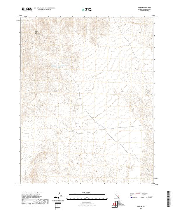
2021 Map of Vigo NE
USGS Topo · Published 2021About this map
The Meadow Valley Mountains dominate this high-desert landscape in Lincoln County, Nevada. The terrain is defined by extreme relief and complex drainage patterns, most notably around Vigo Canyon in the southeastern portion of the map. Water resources are sparse but critical to the character of this area, centered on the Averett Reservoir and its associated natural water points. These sites, including Averett Spring and Hidden Spring, represent the primary points of historical and geological interest in an otherwise unpopulated mountain range. The map clearly delineates the Public Land Survey System grid, specifically identifying townships such as t8s r66e and t9s r67e, which are essential for land-tenure research in the Great Basin region.
Find a feature on this map
9 named features on this map. Tap any name to fly to it.
Don’t see what you’re looking for? This feature index may not catch every label — zoom into the map to look around manually.
Map Details
Editions of this 2021 Vigo NE Map
This is the sole edition of this map. No revisions or reprints were ever made.
Other maps of this area

1885 · Pioche
USGS Topo · 1:250,000

1886 · Pioche
USGS Topo · 1:250,000

1954 · Caliente
USGS Topo · 1:250,000

1959 · Caliente
USGS Topo · 1:250,000

1969 · Vigo NW
USGS Topo · 1:24,000

1969 · Elgin
USGS Topo · 1:24,000
1969 · Vigo
USGS Topo · 1:24,000
1969 · Sunflower Mtn
USGS Topo · 1:24,000
1969 · Vigo NE
USGS Topo · 1:24,000

1969 · Elgin SW
USGS Topo · 1:24,000