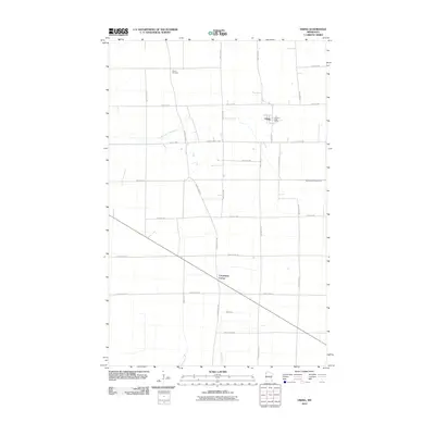
2010 Map of Viking
USGS Topo · Published 2010About this map
Viking sits at the northern edge of this Marshall County landscape, characterized by the grid of rural roads and the winding paths of the South Branch Snake River and Black River. The settlement is anchored by the Viking Post Office and the Viking Cemetery to the north, reflecting a long-established agricultural community. The map traces the historic corridor of the Pembina Trl, a significant regional transit route that runs diagonally across the terrain toward Carpenters Corner. This survey provides a clear view of the section lines and county highways, such as County Hwy-2 and County Hwy-65, that organize the flat, open geography typical of northwest Minnesota. These transport links, from modern county roads to the ancestral trail, highlight how the movement of people and goods has shaped the local land use and community centers over time.
Find a feature on this map
28 named features on this map. Tap any name to fly to it.
Don’t see what you’re looking for? This feature index may not catch every label — zoom into the map to look around manually.
Map Details
Editions of this 2010 Viking Map
This is the sole edition of this map. No revisions or reprints were ever made.
Other maps of this area

1918 · Angus
USGS Topo · 1:62,500

1918 · Viking
USGS Topo · 1:62,500

1952 · Thief River Falls
USGS Topo · 1:250,000

1956 · Thief River Falls
USGS Topo · 1:250,000

1956 · Florian
USGS Topo · 1:62,500

1957 · Thief River Falls
USGS Topo · 1:250,000

1957 · Newfolden
USGS Topo · 1:62,500

1959 · Viking
USGS Topo · 1:24,000

1959 · Rosewood
USGS Topo · 1:24,000
1959 · Viking SW
USGS Topo · 1:24,000