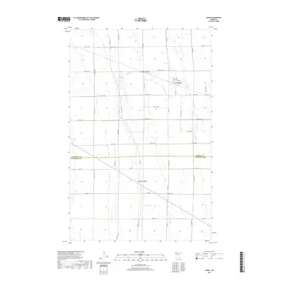
2019 Map of Viking
USGS Topo · Published 2019About this map
The small settlement of Viking serves as the focal point of this Northwest Minnesota survey, where the grid-like agricultural landscape is interrupted by the winding courses of the S Br Snake River and the Black River. This area is historically significant for its location along the Pembina Trl, a legacy route that once facilitated the Red River cart trade between the Red River Colony and Saint Paul. The map preserves the specific orientation of these historical paths, including the Pembina Trl NW, which cut diagonally across the modern section lines. Genealogists will find the Viking Cem northwest of the main town site, while the local road network, including Main St and Viking Rd, illustrates the community's development along the county line between Marshall Co and Pennington Co.
Find a feature on this map
24 named features on this map. Tap any name to fly to it.
Don’t see what you’re looking for? This feature index may not catch every label — zoom into the map to look around manually.
Map Details
Editions of this 2019 Viking Map
This is the sole edition of this map. No revisions or reprints were ever made.
Other maps of this area

1918 · Angus
USGS Topo · 1:62,500

1918 · Viking
USGS Topo · 1:62,500

1952 · Thief River Falls
USGS Topo · 1:250,000

1956 · Thief River Falls
USGS Topo · 1:250,000

1956 · Florian
USGS Topo · 1:62,500

1957 · Thief River Falls
USGS Topo · 1:250,000

1957 · Newfolden
USGS Topo · 1:62,500

1959 · Viking
USGS Topo · 1:24,000

1959 · Rosewood
USGS Topo · 1:24,000
1959 · Viking SW
USGS Topo · 1:24,000