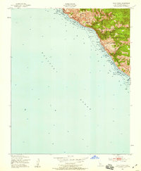
1949 Map of Villa Creek
USGS Topo · Published 1958About this map
The Pacific Ocean shoreline meets the steep, wooded slopes of the Santa Lucia Range in this 1949 survey. Dominated by public and restricted lands, the landscape shows the intersection of the Los Padres National Forest and the southern reaches of the Hunter Liggett Military Reservation. These boundaries create a largely undeveloped coastal corridor where drainage systems like Villa Creek and Alder Creek carve narrow paths toward the sea.
Find a feature on this map
12 named features on this map. Tap any name to fly to it.
Don’t see what you’re looking for? This feature index may not catch every label — zoom into the map to look around manually.
Map Details
Editions of this 1949 Villa Creek Map
5 editions found
Other maps of this area

1919 · Piedras Blancas
USGS Topo · 1:62,500

1921 · Cape San Martin
USGS Topo · 1:62,500

1927 · Piedras Blancas
USGS Topo · 1:62,500

1941 · Cape San Martin
USGS Topo · 1:62,500

1942 · Cape San Martin
USGS Topo · 1:62,500

1947 · San Luis Obispo
USGS Topo · 1:250,000

1948 · San Luis Obispo
USGS Topo · 1:250,000
1948 · Cape San Martin
USGS Topo · 1:62,500
1949 · Villa Creek
USGS Topo · 1:24,000
1949 · Burro Mountain
USGS Topo · 1:24,000