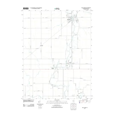
2012 Map of Villa Grove
USGS Topo · Published 2012About this map
The Embarras River meanders south through this section of Douglas County, serving as the geographic spine for several historic Illinois communities. Villa Grove occupies the northern reaches of the map, characterized by a structured grid of streets such as McCoy Ave and Front St, alongside the corridor of Railroad St. Further south, the landscape transitions into agricultural plots and smaller settlements like Camargo and West Ridge.
Find a feature on this map
44 named features on this map. Tap any name to fly to it.
Don’t see what you’re looking for? This feature index may not catch every label — zoom into the map to look around manually.
Map Details
Editions of this 2012 Villa Grove Map
This is the sole edition of this map. No revisions or reprints were ever made.
Other maps of this area

1935 · Arcola
USGS Topo · 1:48,000

1936 · Oakland
USGS Topo · 1:48,000

1940 · Arcola
USGS Topo · 1:62,500

1942 · Oakland
USGS Topo · 1:62,500

1950 · Tuscola
USGS Topo · 1:62,500

1956 · Villa Grove
USGS Topo · 1:62,500

1958 · Decatur
USGS Topo · 1:250,000

1961 · Decatur
USGS Topo · 1:250,000
1975 · Tuscola NE
USGS Topo · 1:24,000
1975 · Tuscola SE
USGS Topo · 1:24,000