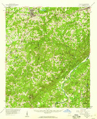
1958 Map of Villa Rica
USGS Topo · Published 1960About this map
Villa Rica stands as a primary hub of commerce and transit in the late 1950s, situated where the Bankhead Highway and Southern Railway parallel each other across the northern Georgia landscape. The map reveals a transition from the industrial activity at Banning Mills in the south to the developing suburban character near Douglasville. The terrain is defined by the winding course of the Chattahoochee River, which forms a natural boundary between Carroll, Douglas, and Fulton counties. Smaller rural settlements like Hickory Level and Winston are connected by a network of local roads including Notch Road and Ferry Road. Cultural life is anchored by numerous community landmarks, such as Fairplay Sch and Bright Star Ch, while the presence of a Microwave Tower and Radio Tower indicates the era's advancing communications infrastructure.
Find a feature on this map
80 named features on this map. Tap any name to fly to it.
Don’t see what you’re looking for? This feature index may not catch every label — zoom into the map to look around manually.
Map Details
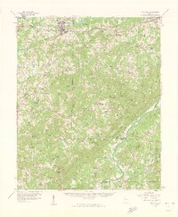
Editions of this 1958 Villa Rica Map
2 editions found
Other maps of this area

1889 · Tallapoosa
USGS Topo · 1:125,000

1891 · Marietta
USGS Topo · 1:125,000

1892 · Tallapoosa
USGS Topo · 1:125,000

1895 · Marietta
USGS Topo · 1:125,000

1897 · Marietta
USGS Topo · 1:125,000

1897 · Tallapoosa
USGS Topo · 1:125,000

1899 · Wedowee
USGS Topo · 1:125,000

1901 · Marietta
USGS Topo · 1:125,000

1902 · Wedowee
USGS Topo · 1:125,000

1953 · Atlanta
USGS Topo · 1:250,000