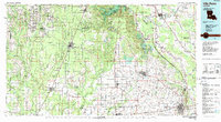
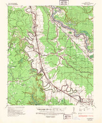
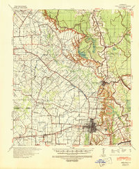
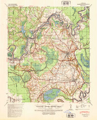
1986 Map of Ville Platte
USGS Topo · Published 1989About this map
Ville Platte serves as the central hub of this South Louisiana landscape, where the agricultural prairies of Evangeline and St. Landry Parishes meet the dense timberlands of the Kisatchie National Forest. The map documents a transition in both terrain and transport, showing the network of bayous like Bayou Teche and Bayou Cocodrie that historically dictated movement, now superseded by the Missouri Pacific RR and Southern Pacific RR lines. Large-scale water features such as Millers Lake and Chicot Lake within Chicot State Park stand out against the geometric grid of rice and crawfish country. Smaller, culturally significant settlements such as Mamou and Chataignier are detailed alongside larger municipal centers like Opelousas and Eunice, revealing the dense settlement patterns of the mid-1980s. The presence of the Mamou Municipal Airport and a complex highway system including Us 190 highlights the region's modernization while maintaining its distinct rural Cajun and Creole identity.
Find a feature on this map
138 named features on this map. Tap any name to fly to it.
Don’t see what you’re looking for? This feature index may not catch every label — zoom into the map to look around manually.
Map Details
Editions of this 1986 Ville Platte Map
2 editions found

Other maps of this area

1935 · Beaver
USGS Topo · 1:31,680
1935 · Mittie
USGS Topo · 1:31,680

1935 · Pawnee
USGS Topo · 1:31,680
1935 · Oakdale
USGS Topo · 1:31,680
1935 · Turkey Creek
USGS Topo · 1:62,500
1935 · Lecompte
USGS Topo · 1:62,500
1939 · Opelousas
USGS Topo · 1:62,500
1940 · Marksville
USGS Topo · 1:62,500

1940 · Arnaudville
USGS Topo · 1:62,500

1941 · Slagle
USGS Topo · 1:62,500