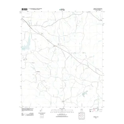
2012 Map of Vimville
USGS Topo · Published 2012About this map
Vimville and the surrounding Lauderdale County countryside are defined by a network of creeks and family-named roads that reflect generations of local settlement. The landscape is dominated by the winding course of Buckatunna Cr and the Long Creek Reservoir, while smaller tributaries like Cokers Br and Tedder Br carve through the terrain. For genealogists, the map provides precise locations for numerous community landmarks including Coker Chapel Cem, Mount Carmel Cem, and Shamburger Cem. Small clusters of homes and farms are noted at Enzor, Increase, and Cliff Williams, connected by historical routes like Old Wire Rd and Old Highway 19 SE. This 2012 survey captures the area before modern expansion might further alter these rural Mississippi neighborhoods, preserving the location of recreational sites such as Camp Binachi and Meridale Camp.
Find a feature on this map
82 named features on this map. Tap any name to fly to it.
Don’t see what you’re looking for? This feature index may not catch every label — zoom into the map to look around manually.
Map Details
Editions of this 2012 Vimville Map
This is the sole edition of this map. No revisions or reprints were ever made.
Other maps of this area

1921 · Meridian
USGS Topo · 1:48,000

1923 · Meridian
USGS Topo · 1:62,500

1953 · Meridian
USGS Topo · 1:250,000

1957 · Meridian
USGS Topo · 1:250,000

1957 · Quitman
USGS Topo · 1:62,500

1965 · Meridian
USGS Topo · 1:250,000

1971 · Vimville
USGS Topo · 1:24,000

1971 · Meridian South
USGS Topo · 1:24,000

1971 · Meridian North
USGS Topo · 1:24,000
1971 · Toomsuba
USGS Topo · 1:24,000