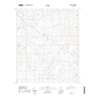
2020 Map of Vimville
USGS Topo · Published 2020About this map
Vimville sits at the heart of this Lauderdale County landscape, where the headwaters of Buckatunna Cr and Alamuchee Cr begin to carve through the terrain. The community structure is defined by its rural intersections and numerous family and community burial grounds, such as Coker Chapel Cem and Mount Carmel Cem. To the west, the Long Creek Reservoir provides a significant water feature near the small settlement of Enzor. Further south, the map reaches the community of Increase, illustrating a late-century pattern of dispersed residential growth connected by long-established routes like Old Wire Rd and Old Hwy 19 SE. The abundance of named cemeteries, including Shamburger Cem and Pleasant Grove Cem, makes this an essential document for tracing local family history and the geographic layout of parish and community life in this portion of Mississippi.
Find a feature on this map
82 named features on this map. Tap any name to fly to it.
Don’t see what you’re looking for? This feature index may not catch every label — zoom into the map to look around manually.
Map Details
Editions of this 2020 Vimville Map
This is the sole edition of this map. No revisions or reprints were ever made.
Other maps of this area

1921 · Meridian
USGS Topo · 1:48,000

1923 · Meridian
USGS Topo · 1:62,500

1953 · Meridian
USGS Topo · 1:250,000

1957 · Meridian
USGS Topo · 1:250,000

1957 · Quitman
USGS Topo · 1:62,500

1965 · Meridian
USGS Topo · 1:250,000

1971 · Vimville
USGS Topo · 1:24,000

1971 · Meridian South
USGS Topo · 1:24,000

1971 · Meridian North
USGS Topo · 1:24,000
1971 · Toomsuba
USGS Topo · 1:24,000