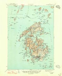
1944 Map of Vinalhaven
USGS Topo · Published 1947About this map
Vinalhaven and North Haven anchor this mid-century survey of the Fox Islands in Penobscot Bay. The intricate coastline of Calderwood Neck and the deep indentation of Southern Harbor reveal a landscape defined by maritime activity and granite quarrying history. Navigation is guided by several critical beacons including Browns Head LH, Goose Rocks LH, and Heron Neck LH, which mark the treacherous passages through Hurricane Sound and Leadbetter Narrows. Local genealogy is anchored at the Seaview Cem and the concentrated settlement at Carvers Harbor. The map illustrates a complex archipelago where interior freshwater bodies like Long Pond and Fresh Pond sit just yards away from the salt water of The Basin and Winter Harbor.
Find a feature on this map
152 named features on this map. Tap any name to fly to it.
Don’t see what you’re looking for? This feature index may not catch every label — zoom into the map to look around manually.
Map Details
Editions of this 1944 Vinalhaven Map
2 editions found

Other maps of this area

1902 · Castine
USGS Topo · 1:62,500

1904 · Deer Isle
USGS Topo · 1:62,500

1904 · Castine
USGS Topo · 1:62,500

1904 · Bluehill
USGS Topo · 1:62,500

1904 · Vinalhaven
USGS Topo · 1:62,500

1904 · Tenants Harbor
USGS Topo · 1:62,500

1904 · Rockland
USGS Topo · 1:62,500

1905 · Penobscot Bay
USGS Topo · 1:125,000

1906 · Matinicus
USGS Topo · 1:62,500

1906 · Tennant Harbor
USGS Topo · 1:62,500