
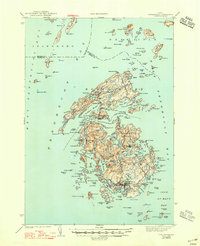
1944 Map of Vinalhaven
USGS Topo · Published 1944About this map
North Haven and the island of Vinalhaven anchor this complex coastal survey of the Fox Islands in the mid-1940s. The maritime landscape is defined by deep incisions like Seal Bay and The Basin, where the rugged granite coastline meets the waters of Penobscot Bay and Isle Au Haut Bay. Settlement patterns are clustered around protected anchorages, most notably at Carvers Harbor and Pulpit Harbor, reflecting a late-era fishing and quarrying economy.
Find a feature on this map
156 named features on this map. Tap any name to fly to it.
Don’t see what you’re looking for? This feature index may not catch every label — zoom into the map to look around manually.
Map Details
Editions of this 1944 Vinalhaven Map
2 editions found
Other maps of this area

1902 · Castine
USGS Topo · 1:62,500

1904 · Deer Isle
USGS Topo · 1:62,500

1904 · Castine
USGS Topo · 1:62,500

1904 · Bluehill
USGS Topo · 1:62,500

1904 · Vinalhaven
USGS Topo · 1:62,500

1904 · Tenants Harbor
USGS Topo · 1:62,500

1904 · Rockland
USGS Topo · 1:62,500

1905 · Penobscot Bay
USGS Topo · 1:125,000

1906 · Matinicus
USGS Topo · 1:62,500

1906 · Tennant Harbor
USGS Topo · 1:62,500