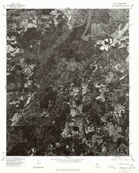
1975 Map of Vincent
USGS Topo · Published 1977About this map
Vincent appears here in the mid-1970s, captured through a high-altitude orthophotograph that reveals the landscape of Shelby County with photographic clarity. Produced by the U.S. Geological Survey in cooperation with the Soil Conservation Service, this imagery documents the spatial relationship between the town center and the surrounding rural terrain. The rectified photoimagery allows for a precise study of land use, showing the distinct patterns of forest cover, agricultural clearings, and the early suburban-style road network radiating from the community hub. This specific survey serves as a vital record for understanding the area's transition before late-twentieth-century development altered the local geography.
Find a feature on this map
1 named feature on this map. Tap any name to fly to it.
Don’t see what you’re looking for? This feature index may not catch every label — zoom into the map to look around manually.
Map Details
Editions of this 1975 Vincent Map
This is the sole edition of this map. No revisions or reprints were ever made.
Other maps of this area

1889 · Springville
USGS Topo · 1:125,000

1889 · Birmingham
USGS Topo · 1:125,000

1890 · Bessemer
USGS Topo · 1:125,000

1890 · Talladega
USGS Topo · 1:125,000

1892 · Birmingham
USGS Topo · 1:125,000

1892 · Springville
USGS Topo · 1:125,000

1892 · Talladega
USGS Topo · 1:125,000

1892 · Bessemer
USGS Topo · 1:125,000

1895 · Birmingham
USGS Topo · 1:125,000

1905 · Leeds
USGS Topo · 1:62,500