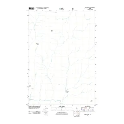
2011 Map of Vinegar Hill
USGS Topo · Published 2011About this map
Vinegar Hill stands as a central landmark in this Idaho wilderness, where the landscape is defined by a dense network of drainage systems and high-altitude aviation points. The southern border is dominated by the flow of Big Creek, which collects waters from numerous tributaries including Garden Creek, Spring Creek, and Cabin Creek. This area is notable for its backcountry accessibility, featuring specialized landing sites such as the Mile Hi Landing Strip, Vines Landing Strip, and the Cabin Creek-US Forest Service Airport. In the northern reaches, Cold Mountain and Cold Mountain Ridge provide significant elevation, anchored by the Cold Mountain Lookout. The map illustrates a terrain where travel is dictated by natural gaps like Blackburn Saddle and the varied basins and ridges that separate the steep creek valleys of the South Fork Cottonwood Creek and East Fork Crooked Creek watersheds.
Find a feature on this map
22 named features on this map. Tap any name to fly to it.
Don’t see what you’re looking for? This feature index may not catch every label — zoom into the map to look around manually.
Map Details
Editions of this 2011 Vinegar Hill Map
This is the sole edition of this map. No revisions or reprints were ever made.
Other maps of this area

1956 · Elk City
USGS Topo · 1:250,000

1960 · Elk City
USGS Topo · 1:250,000

1962 · Mormon Mtn
USGS Topo · 1:24,000

1962 · Vinegar Hill
USGS Topo · 1:24,000

1962 · Papoose Peak
USGS Topo · 1:24,000

1962 · Dave Lewis Peak
USGS Topo · 1:24,000

1973 · Acorn Butte
USGS Topo · 1:24,000
1973 · Monument
USGS Topo · 1:24,000

1977 · Cottonwood Butte
USGS Topo · 1:24,000

1978 · Wapiti Creek
USGS Topo · 1:24,000