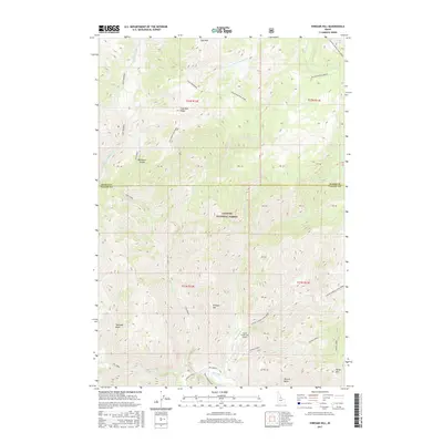
2017 Map of Vinegar Hill
USGS Topo · Published 2017About this map
Vinegar Hill and the surrounding high country of the Payette National Forest define this landscape along the border of Idaho and Valley counties. The terrain is characterized by a complex network of ridges and drainages, where Big Creek and Coyote Spring/Cow Creek flow through deep basins. A key point of access in this backcountry is the Cabin Creek USFS Airport, situated near the confluence of Cabin Creek and Big Creek. This airstrip serves as a critical link for the Forest Service in managing the vast roadless areas between Cold Mountain to the north and Horse Mountain to the south. The map provides a look at the remote geography of the Salmon River Mountains, detailing high points like Rush Creek Point and the depressions of Towhead Basin and Browns Basin.
Find a feature on this map
45 named features on this map. Tap any name to fly to it.
Don’t see what you’re looking for? This feature index may not catch every label — zoom into the map to look around manually.
Map Details
Editions of this 2017 Vinegar Hill Map
This is the sole edition of this map. No revisions or reprints were ever made.
Other maps of this area

1956 · Elk City
USGS Topo · 1:250,000

1960 · Elk City
USGS Topo · 1:250,000

1962 · Mormon Mtn
USGS Topo · 1:24,000

1962 · Vinegar Hill
USGS Topo · 1:24,000

1962 · Papoose Peak
USGS Topo · 1:24,000

1962 · Dave Lewis Peak
USGS Topo · 1:24,000

1973 · Acorn Butte
USGS Topo · 1:24,000
1973 · Monument
USGS Topo · 1:24,000

1977 · Cottonwood Butte
USGS Topo · 1:24,000

1978 · Wapiti Creek
USGS Topo · 1:24,000