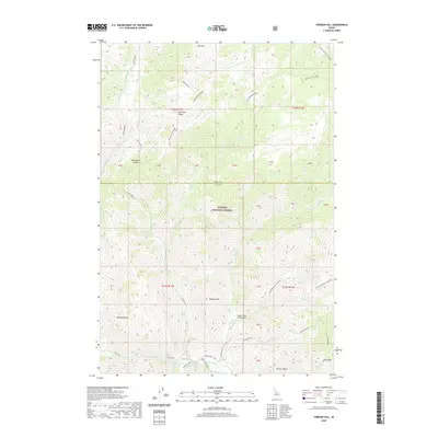
2020 Map of Vinegar Hill
USGS Topo · Published 2020About this map
Payette National Forest dominates this high-altitude landscape where Idaho and Valley Counties meet. The area is defined by sharp elevation shifts between prominent peaks such as Cold Mountain and Vinegar Hill. Remote aviation access is provided by the Cabin Creek USFS Airport, situated along the winding path of Cabin Creek. Drainage networks including Big Creek and Coyote Spring / Cow Creek carve through the terrain, creating natural basins like Towhead Basin and Browns Basin. The map captures a moment in the modern era where wildland management and topographical surveying intersect, preserving the nomenclature of landmarks like Blackburn Saddle and Cold Mountain Ridge that have long served as navigational anchors in this portion of the Salmon River mountains.
Find a feature on this map
44 named features on this map. Tap any name to fly to it.
Don’t see what you’re looking for? This feature index may not catch every label — zoom into the map to look around manually.
Map Details
Editions of this 2020 Vinegar Hill Map
This is the sole edition of this map. No revisions or reprints were ever made.
Other maps of this area

1956 · Elk City
USGS Topo · 1:250,000

1960 · Elk City
USGS Topo · 1:250,000

1962 · Mormon Mtn
USGS Topo · 1:24,000

1962 · Vinegar Hill
USGS Topo · 1:24,000

1962 · Papoose Peak
USGS Topo · 1:24,000

1962 · Dave Lewis Peak
USGS Topo · 1:24,000

1973 · Acorn Butte
USGS Topo · 1:24,000
1973 · Monument
USGS Topo · 1:24,000

1977 · Cottonwood Butte
USGS Topo · 1:24,000

1978 · Wapiti Creek
USGS Topo · 1:24,000