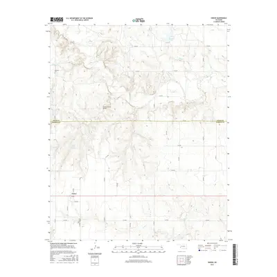
2016 Map of Vinson
USGS Topo · Published 2016About this map
Vinson sits at the southwestern edge of this landscape, marking a transition between the organized grid of Harmon County and the dissected terrain along the Greer Co line. The area is defined by a dense network of watercourses, including Root Cr and Hackberry Cr, which have carved deep drainage patterns through the local geology. One of the most distinctive landmarks is the Vinson Natural Bridge, a significant topographical feature situated north of the main settlement. For those tracing local history, the map includes the locations of Hackberry Cem and Cave Creek Cem, alongside several water management features such as the Russell Overton Reservoir and Doc Hollis Lake. The road system, labeled with identifiers like E1400 Rd and N1740 Rd, illustrates the rural infrastructure supporting these small Oklahoma communities.
Find a feature on this map
33 named features on this map. Tap any name to fly to it.
Don’t see what you’re looking for? This feature index may not catch every label — zoom into the map to look around manually.
Map Details
Editions of this 2016 Vinson Map
This is the sole edition of this map. No revisions or reprints were ever made.
Other maps of this area

1955 · Lawton
USGS Topo · 1:250,000

1955 · Clinton
USGS Topo · 1:250,000

1957 · Clinton
USGS Topo · 1:250,000

1961 · Willow
USGS Topo · 1:62,500

1961 · Erick
USGS Topo · 1:62,500

1971 · Russell
USGS Topo · 1:24,000
1971 · Madge
USGS Topo · 1:24,000

1971 · Vinson
USGS Topo · 1:24,000
1971 · Mc Knight
USGS Topo · 1:24,000

1971 · Reed
USGS Topo · 1:24,000