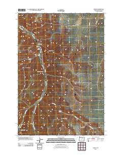
2011 Map of Vinson
USGS Topo · Published 2011About this map
Vinson (historical) anchors this high-desert landscape in Umatilla County, marking a localized pocket of settlement along the winding path of Butter Creek. The map reveals a drainage system defined by deep geographic incisions like Vinson Canyon and Kramer Canyon, which cut through the plateaus of the Columbia Basin. For genealogists and local historians, the Vinson Cemetery serves as a critical point of interest, situated just south of the historic townsite. The terrain is characterized by a series of named draws and hollows, including Dry Hog Hollow and Nelson Canyon, which demonstrate how the early ranching and agricultural economy was shaped by the specific topography of the creek valleys. Transport is facilitated by rural routes such as Gurdane Rd and CO 1396 Rd, which link these remote canyons to the broader regional network.
Find a feature on this map
22 named features on this map. Tap any name to fly to it.
Don’t see what you’re looking for? This feature index may not catch every label — zoom into the map to look around manually.
Map Details
Editions of this 2011 Vinson Map
This is the sole edition of this map. No revisions or reprints were ever made.
Other maps of this area

1908 · Umatilla
USGS Topo · 1:125,000

1935 · Pendleton
USGS Topo · 1:125,000

1953 · Pendleton
USGS Topo · 1:250,000

1956 · Pendleton
USGS Topo · 1:250,000
1966 · Coombs Canyon
USGS Topo · 1:24,000

1967 · Nye
USGS Topo · 1:24,000

1967 · Carney Butte
USGS Topo · 1:24,000

1968 · Hoodlum Canyon
USGS Topo · 1:24,000
1968 · Echo SE
USGS Topo · 1:24,000

1968 · Gurdane
USGS Topo · 1:24,000