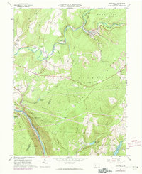
1964 Map of Vintondale
USGS Topo · Published 1973About this map
Vintondale stands as a central industrial hub along the Penn Central rail line, where the North Branch Blacklick Creek and South Branch Blacklick Creek converge. The landscape in the mid-1960s is defined by its extractive economy, featuring numerous Strip Mine operations and a significant Mine Dump near Rexis. This industrial footprint contrasts sharply with the nearby State Game Lands No 79 and the prominent heights of Laurel Ridge.
Find a feature on this map
62 named features on this map. Tap any name to fly to it.
Don’t see what you’re looking for? This feature index may not catch every label — zoom into the map to look around manually.
Map Details
Editions of this 1964 Vintondale Map
3 editions found
Other maps of this area

1902 · Indiana
USGS Topo · 1:62,500

1902 · Barnesboro
USGS Topo · 1:62,500

1904 · Barnesboro
USGS Topo · 1:62,500

1904 · Johnstown
USGS Topo · 1:62,500

1907 · Johnstown
USGS Topo · 1:62,500

1920 · New Florence
USGS Topo · 1:62,500

1921 · New Florence
USGS Topo · 1:48,000

1922 · New Florence
USGS Topo · 1:62,500

1943 · Punxsutawney
USGS Topo · 1:125,000

1944 · New Florence
USGS Topo · 1:62,500
Featured Places
- Vintondale, PA
- Middle Taylor Township, PA
- West Taylor Township, PA
- Lower Yoder Township, PA
- Saint Clair Township, PA