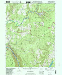
1998 Map of Vintondale
USGS Topo · Published 1999About this map
Blacklick Creek carves a deep valley through the northern half of this terrain, where the borough of Vintondale stands as a focal point of industrial history near the junction of South Branch and North Branch. The landscape reflects a legacy of extraction, with numerous labels for Mine Dumps, Strip Mines, and local pits scattered across the hillsides of Laurel Hill. These industrial features are interspersed with community landmarks like Delano Sch, Blacklick Ch, and Memorial Ch in Dilltown.
Find a feature on this map
55 named features on this map. Tap any name to fly to it.
Don’t see what you’re looking for? This feature index may not catch every label — zoom into the map to look around manually.
Map Details
Editions of this 1998 Vintondale Map
This is the sole edition of this map. No revisions or reprints were ever made.
Other maps of this area

1902 · Indiana
USGS Topo · 1:62,500

1902 · Barnesboro
USGS Topo · 1:62,500

1904 · Barnesboro
USGS Topo · 1:62,500

1904 · Johnstown
USGS Topo · 1:62,500

1907 · Johnstown
USGS Topo · 1:62,500

1920 · New Florence
USGS Topo · 1:62,500

1921 · New Florence
USGS Topo · 1:48,000

1922 · New Florence
USGS Topo · 1:62,500

1943 · Punxsutawney
USGS Topo · 1:125,000

1944 · New Florence
USGS Topo · 1:62,500
Featured Places
- Vintondale, PA
- Middle Taylor Township, PA
- West Taylor Township, PA
- Lower Yoder Township, PA
- Saint Clair Township, PA