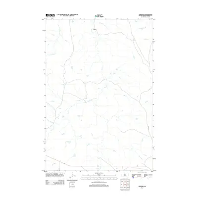
2012 Map of Virginia
USGS Topo · Published 2012About this map
Virginia serves as the central settlement point in this Dewey County landscape, situated where the northern prairie transitions through a series of creek drainages. The area is defined by its water network, most notably the meandering course of Virgin Cr which flows toward the center of the quadrangle. Other significant waterways include Left Hand Bear Cr in the northwest and the upper reaches of Buffalo Cr and E Fork Beaver Cr in the northeast. This 2012 survey illustrates a sparsely populated region of South Dakota where movement is guided by rural routes such as Co HWY-14f and Co HWY-14g. The geography is characterized by numerous small prairie potholes and seasonal water bodies scattered across the terrain, reflecting the natural hydrology of the Missouri Plateau prior to significant modern development.
Find a feature on this map
7 named features on this map. Tap any name to fly to it.
Don’t see what you’re looking for? This feature index may not catch every label — zoom into the map to look around manually.
Map Details
Editions of this 2012 Virginia Map
This is the sole edition of this map. No revisions or reprints were ever made.
Other maps of this area

1951 · Virginia
USGS Topo · 1:24,000

1951 · La Plant
USGS Topo · 1:24,000

1951 · Promise
USGS Topo · 1:24,000

1952 · Trail City SW
USGS Topo · 1:24,000

1953 · McIntosh
USGS Topo · 1:250,000

1958 · McIntosh
USGS Topo · 1:250,000

1968 · Moreau
USGS Topo · 1:24,000

1969 · Patch Skin Buttes SW
USGS Topo · 1:24,000

1970 · Patch Skin Buttes
USGS Topo · 1:24,000
1981 · Stove Creek
USGS Topo · 1:24,000