1926 Map of Viroqua
USGS Topo · Published 1926About this map
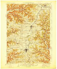
Viroqua serves as the focal point of this mid-1920s topographical study, situated at the junction of the Chicago Milwaukee and St. Paul railroad and major early thoroughfares like State Highway No. 11. The landscape is defined by the complex drainage of the Bad Axe River and its branches, including the South Fork Bad Axe River and Bishop Branch. Rural life is meticulously documented through a dense network of country schoolhouses such as Belgium Ridge School, Clockmaker School, and Colonel May School. Notable community institutions like the Vernon County Asylum and Coon Prairie Church appear alongside the smaller settlements of Westby, Cashton, and Avalanche. The terrain transitions from high ridges like Bingham Ridge to deep coulees such as Randall Coulee, reflecting the intricate geography of Vernon and Monroe counties before modern development.
Find a feature on this map
91 named features on this map. Tap any name to fly to it.
Don’t see what you’re looking for? This feature index may not catch every label — zoom into the map to look around manually.
Map Details
Editions of this 1926 Viroqua Map
2 editions found
Other maps of this area

1903 · Waukon
USGS Topo · 1:125,000

1909 · Sparta
USGS Topo · 1:62,500

1916 · Tomah
USGS Topo · 1:62,500

1923 · Viroqua
USGS Topo · 1:62,500

1924 · Gays Mills
USGS Topo · 1:62,500

1926 · Gays Mills
USGS Topo · 1:62,500

1926 · Stoddard
USGS Topo · 1:62,500

1926 · Viroqua
USGS Topo · 1:62,500

1926 · La Farge
USGS Topo · 1:62,500

1927 · La Crosse
USGS Topo · 1:62,500