1965 Map of Viroqua
USGS Topo · Published 1979About this map
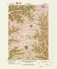
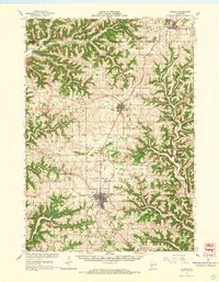
Viroqua serves as the focal point of this Vernon County landscape, situated atop the prominent Coon Prairie and Round Prairie systems. The map illustrates a transitional era where traditional agricultural hubs like Westby and Cashton remain tied to the Chicago Milwaukee St Paul and Pacific rail line. The terrain is deeply defined by a series of narrow valleys and ridges, including Bohemian Ridge and Clinton Ridge, which separate the headwaters of the Kickapoo River from the drainage of the Bad Axe River. Genealogists will find a wealth of local landmarks, from the Sacred Heart Ch in the north to the Brookville Cem in the south, alongside numerous country schools such as Clockmaker Sch and Nerison Sch that once anchored these rural neighborhoods.
Find a feature on this map
92 named features on this map. Tap any name to fly to it.
Don’t see what you’re looking for? This feature index may not catch every label — zoom into the map to look around manually.
Map Details
Editions of this 1965 Viroqua Map
2 editions found
Other maps of this area

1903 · Waukon
USGS Topo · 1:125,000

1909 · Sparta
USGS Topo · 1:62,500

1916 · Tomah
USGS Topo · 1:62,500

1923 · Viroqua
USGS Topo · 1:62,500

1924 · Gays Mills
USGS Topo · 1:62,500

1926 · Gays Mills
USGS Topo · 1:62,500

1926 · Stoddard
USGS Topo · 1:62,500

1926 · Viroqua
USGS Topo · 1:62,500

1926 · La Farge
USGS Topo · 1:62,500

1927 · La Crosse
USGS Topo · 1:62,500