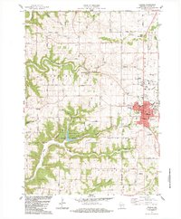
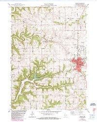
1983 Map of Viroqua
USGS Topo · Published 1983About this map
Rolling Hills and deep-cut hollows characterize this portion of Vernon County, where the driftless topography is defined by the North Fork Bad Axe River and its numerous tributaries. The city of Viroqua serves as the regional hub, showing a detailed 1980s street grid including an Armory, Hosp, and a Fairground. To the west, the village of Springville sits along the Springville Branch, while the creation of Sidie Hollow Lake within Sidie Hollow County Park provides a central landmark for the surrounding ridge country.
Find a feature on this map
67 named features on this map. Tap any name to fly to it.
Don’t see what you’re looking for? This feature index may not catch every label — zoom into the map to look around manually.
Map Details
Editions of this 1983 Viroqua Map
2 editions found
Other maps of this area

1903 · Waukon
USGS Topo · 1:125,000

1923 · Viroqua
USGS Topo · 1:62,500

1924 · Gays Mills
USGS Topo · 1:62,500

1926 · Gays Mills
USGS Topo · 1:62,500

1926 · Stoddard
USGS Topo · 1:62,500

1926 · Viroqua
USGS Topo · 1:62,500

1929 · Ferryville
USGS Topo · 1:62,500
1932 · Ferryville
USGS Topo · 1:62,500

1958 · La Crosse
USGS Topo · 1:250,000

1961 · La Crosse
USGS Topo · 1:250,000