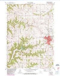
1983 Map of Viroqua
USGS Topo · Published 1985About this map
Viroqua serves as the focal point of this Vernon County landscape, appearing as it did in the early 1980s with a dense concentration of civic infrastructure including the High Sch, Hosp, and Armory. The surrounding terrain is defined by the Rolling Hills and deep drainage systems like Sidie Hollow, where the Sidie Hollow County Park and its Boat Ramp provide recreation on the reservoir. Traces of early settlement and genealogy remain scattered across the ridges, from the Bethel Ch and its adjacent Bethel Cem to the isolated Asbury Cem and Belgium Ridge Cem. To the north, the distinctive Three Chimneys rock formation stands near Coon Prairie, while the town's growth is marked by the Viroqua Municipal Airport and the sprawling Fairground on the eastern edge of the city.
Find a feature on this map
65 named features on this map. Tap any name to fly to it.
Don’t see what you’re looking for? This feature index may not catch every label — zoom into the map to look around manually.
Map Details
Editions of this 1983 Viroqua Map
2 editions found
Other maps of this area

1903 · Waukon
USGS Topo · 1:125,000

1923 · Viroqua
USGS Topo · 1:62,500

1924 · Gays Mills
USGS Topo · 1:62,500

1926 · Gays Mills
USGS Topo · 1:62,500

1926 · Stoddard
USGS Topo · 1:62,500

1926 · Viroqua
USGS Topo · 1:62,500

1929 · Ferryville
USGS Topo · 1:62,500

1932 · Ferryville
USGS Topo · 1:62,500

1958 · La Crosse
USGS Topo · 1:250,000

1961 · La Crosse
USGS Topo · 1:250,000