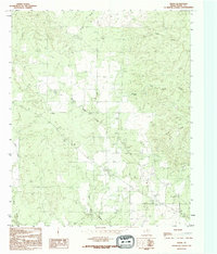
1990 Map of Vivian
USGS Topo · Published 1995About this map
Vivian serves as the primary point of settlement in this northern Texas landscape, situated in an area of Foard County defined by a complex network of seasonal drainages. Compiled from late 1970s imagery and verified in the mid-1990s, the map illustrates a rural environment where land use revolves around ranching, specifically at the V Ranch. Water sources are critical landmarks here, including the Half Circle Spring and the distinctive Blue Hole Creek. The terrain is deeply carved by numerous waterways such as Cactus Creek, Cedar Creek, and Good Creek, which dictate the placement of roads and structures. Genealogists may find value in the location of a local Cem, while the presence of a Roadside Park reflects the modest infrastructure supporting travel through this ranching country. The map provides a clear view of the Texas Panhandle's eastern edge before significant modern development altered the remote character of the area.
Find a feature on this map
11 named features on this map. Tap any name to fly to it.
Don’t see what you’re looking for? This feature index may not catch every label — zoom into the map to look around manually.
Map Details
Editions of this 1990 Vivian Map
This is the sole edition of this map. No revisions or reprints were ever made.
Other maps of this area

1927 · Quanah 3-a
USGS Topo · 1:48,000

1927 · Quanah 3-b
USGS Topo · 1:48,000

1932 · Vivian
USGS Topo · 1:62,500

1954 · Lubbock
USGS Topo · 1:250,000

1954 · Plainview
USGS Topo · 1:250,000

1954 · Wichita Falls
USGS Topo · 1:250,000

1955 · Lawton
USGS Topo · 1:250,000

1958 · Wichita Falls
USGS Topo · 1:250,000

1958 · Plainview
USGS Topo · 1:250,000

1960 · Teacup Mountain
USGS Topo · 1:62,500