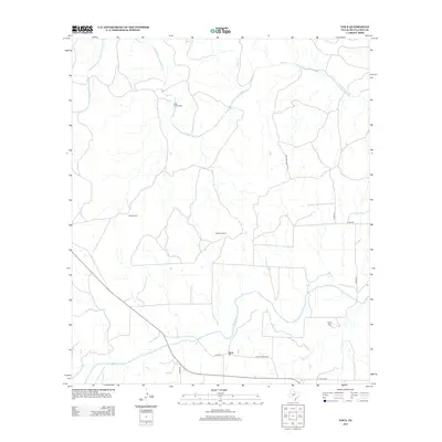
2012 Map of Voca
USGS Topo · Published 2012About this map
The San Saba River defines the southern portion of this landscape near Voca, where Ranch Road 1851 and various county roads meet the river's path. This area of McCulloch County is characterized by large rural holdings such as the Stephens Ranch and Brook Ranch, reflecting the long-standing ranching traditions of the Texas Hill Country region. To the north, the terrain is drained by the winding course of Brady Cr, which is joined by Onion Cr and features the Brady Creek Lodge along its banks. Local family history and genealogy are anchored by the Spiller Cem, situated near Lost Cr on the eastern side of the survey. The map reveals a network of rural routes, including Brasade Ranch Rd and Co Rd-214, that link these isolated homesteads and water sources.
Find a feature on this map
18 named features on this map. Tap any name to fly to it.
Don’t see what you’re looking for? This feature index may not catch every label — zoom into the map to look around manually.
Map Details
Editions of this 2012 Voca Map
This is the sole edition of this map. No revisions or reprints were ever made.
Other maps of this area

1887 · Mason
USGS Topo · 1:125,000

1894 · Brady
USGS Topo · 1:125,000

1894 · Mason
USGS Topo · 1:125,000

1954 · Brownwood
USGS Topo · 1:250,000

1954 · Llano
USGS Topo · 1:250,000

1955 · Llano
USGS Topo · 1:250,000

1956 · Llano
USGS Topo · 1:250,000

1960 · Brady North
USGS Topo · 1:24,000
1962 · Fredonia
USGS Topo · 1:24,000

1963 · Spy Rock
USGS Topo · 1:24,000