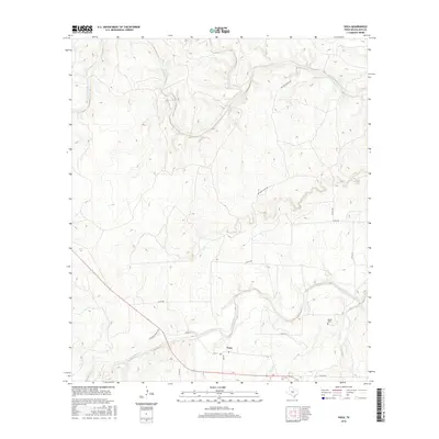
2016 Map of Voca
USGS Topo · Published 2016About this map
The San Saba River meanders across the southern portion of this landscape, serving as a primary hydrologic artery for the small settlement of Voca. This Texas Hill Country terrain is defined by a dendritic drainage pattern where Brady Cr and Onion Cr carve through the limestone-dominated plateau to the north. The area maintains a low-density, rural character centered on ranching and family heritage, evidenced by the presence of the Spiller Cem near the banks of Lost Cr. Transportation in the region relies on a network of rural routes such as Brasade Ranch Rd and Nichols Rolucia Rd, which connect isolated homesteads to the river valley. The map documents the persistent rural footprint of McCulloch County, where the convergence of Tiger Cr and the San Saba remains a central geographic landmark.
Find a feature on this map
16 named features on this map. Tap any name to fly to it.
Don’t see what you’re looking for? This feature index may not catch every label — zoom into the map to look around manually.
Map Details
Editions of this 2016 Voca Map
This is the sole edition of this map. No revisions or reprints were ever made.
Other maps of this area

1887 · Mason
USGS Topo · 1:125,000

1894 · Brady
USGS Topo · 1:125,000

1894 · Mason
USGS Topo · 1:125,000

1954 · Brownwood
USGS Topo · 1:250,000

1954 · Llano
USGS Topo · 1:250,000

1955 · Llano
USGS Topo · 1:250,000

1956 · Llano
USGS Topo · 1:250,000

1960 · Brady North
USGS Topo · 1:24,000
1962 · Fredonia
USGS Topo · 1:24,000

1963 · Spy Rock
USGS Topo · 1:24,000