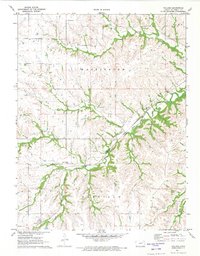
1971 Map of Volland
USGS Topo · Published 1973About this map
Volland sits at a strategic bend in the Chicago Rock Island and Pacific railroad, serving as a primary point of interest in this 1971 survey of Wabaunsee County. The landscape is defined by the winding course of the West Branch Mill Creek and Spring Creek, which cut through the townships of Washington and Garfield. For genealogists and local historians, the map provides precise locations for several burial grounds, including Fix Cem, Templin Cem, and East Templin Cem. The presence of a Quarry and the extensive rail infrastructure highlights the local industry and transportation networks that shaped this Kansas prairie region during the early 1970s. The proximity to Alma at the northeast edge of the quadrangle further orients this study of rural Kansas development.
Find a feature on this map
11 named features on this map. Tap any name to fly to it.
Don’t see what you’re looking for? This feature index may not catch every label — zoom into the map to look around manually.
Map Details
Editions of this 1971 Volland Map
This is the sole edition of this map. No revisions or reprints were ever made.
Other maps of this area

1885 · Eskridge
USGS Topo · 1:125,000

1886 · Junction City
USGS Topo · 1:125,000

1889 · Wamego
USGS Topo · 1:125,000

1889 · Junction City
USGS Topo · 1:125,000

1889 · Parkerville
USGS Topo · 1:125,000

1889 · Eskridge
USGS Topo · 1:125,000

1894 · Eskridge
USGS Topo · 1:125,000

1894 · Junction City
USGS Topo · 1:125,000

1894 · Parkerville
USGS Topo · 1:125,000

1894 · Wamego
USGS Topo · 1:125,000