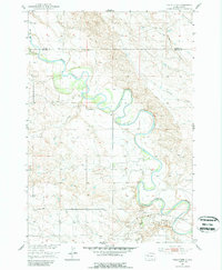
1951 Map of Volunteer
USGS Topo · Published 1989About this map
The Belle Fourche River dominates this mid-century landscape in the Missouri River Basin, carving a winding path through the borderlands of Butte and Meade Counties. At this time, the area's rural character is defined by a sparse network of section-line roads connecting small educational outposts such as Wetz Sch, Meyer Sch, and Fourmile Sch. These small schools served the outlying farmsteads and the community of Volunteer, which sits at the junction of local transit routes near the river's lower bends.
Find a feature on this map
12 named features on this map. Tap any name to fly to it.
Don’t see what you’re looking for? This feature index may not catch every label — zoom into the map to look around manually.
Map Details
Editions of this 1951 Volunteer Map
3 editions found
Other maps of this area

1893 · Rapid
USGS Topo · 1:125,000

1898 · Rapid
USGS Topo · 1:125,000

1903 · Rapid
USGS Topo · 1:125,000

1906 · Vale
USGS Topo · 1:62,500

1913 · Newell
USGS Topo · 1:125,000

1951 · Volunteer
USGS Topo · 1:24,000

1951 · Volunteer SE
USGS Topo · 1:24,000

1951 · Vale SE
USGS Topo · 1:24,000

1951 · Vale NE
USGS Topo · 1:24,000

1951 · Vale
USGS Topo · 1:62,500