
1941 Map of Voorhies
USGS Topo · Published 1943About this map
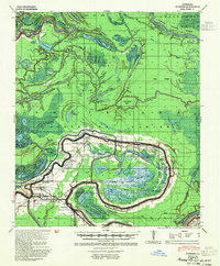
Bayou des Glaises snakes through this low-lying landscape, defining the settlement patterns of Avoyelles Parish in the early 1940s. The map reveals a community structured around the water and the Texas & Pacific RR, with small towns like Bordelonville, Moreauville, and Hamburg established along these corridors. The density of spiritual and educational centers is striking, featuring numerous named sites such as St Peter Ch & Cem and the Voorhies School.
Find a feature on this map
82 named features on this map. Tap any name to fly to it.
Don’t see what you’re looking for? This feature index may not catch every label — zoom into the map to look around manually.
Map Details
Editions of this 1941 Voorhies Map
2 editions found
Other maps of this area

1935 · Tooleys
USGS Topo · 1:62,500

1939 · Artonish
USGS Topo · 1:62,500

1939 · Deer Park
USGS Topo · 1:62,500

1940 · Marksville
USGS Topo · 1:62,500

1941 · Buckeye
USGS Topo · 1:62,500

1941 · Batchelor
USGS Topo · 1:62,500

1941 · Tooleys
USGS Topo · 1:62,500

1948 · Bunkie
USGS Topo · 1:62,500

1952 · Lake Charles
USGS Topo · 1:250,000

1953 · Alexandria
USGS Topo · 1:250,000