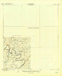
1932 Map of Voss
USGS Topo · Published 1949About this map
The Colorado River and Concho River converge in this West Texas survey, marking a rugged landscape where Runnels, Concho, and Coleman counties meet. Before the era of modern bridges, local transport relied on numerous river crossings such as Trap Crossing, Coffee Ford, and Gin Ford. These shallow points were vital for the rural economy, connecting isolated ranching communities and local schools like Grape Creek Sch and Liberty Sch.
Find a feature on this map
21 named features on this map. Tap any name to fly to it.
Don’t see what you’re looking for? This feature index may not catch every label — zoom into the map to look around manually.
Map Details
Editions of this 1932 Voss Map
2 editions found

Other maps of this area

1887 · Coleman
USGS Topo · 1:125,000

1889 · Coleman
USGS Topo · 1:125,000

1892 · Eden
USGS Topo · 1:125,000

1892 · Ballinger
USGS Topo · 1:125,000

1894 · Brady
USGS Topo · 1:125,000

1896 · Eden
USGS Topo · 1:125,000

1924 · Eden 1-a
USGS Topo · 1:48,000

1925 · Brady 2-b
USGS Topo · 1:48,000

1925 · Ballinger 3-d
USGS Topo · 1:48,000

1925 · Ballinger 4-c
USGS Topo · 1:48,000