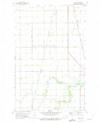
1972 Map of Voss
USGS Topo · Published 1975About this map
Voss and Minto anchor this prairie landscape in the Red River Valley during the early 1970s. The agricultural character of the region is defined by the rigid township and range grid, where individual farmsteads are connected by a network of section-line roads. The Burlington Northern railroad serves as the primary industrial artery, running north-south to connect the small trackside elevators and shipping points at Kellogg and Herriott. In the southern portion of the sheet, the flat plains give way to the more complex topography of the Forest River valley. This waterway meanders through the townships of Forest River and Ardoch, providing a sharp contrast to the geometric precision of the surrounding Walsh Centre farmlands. The map illustrates a moment in Walsh County history when these small railroad settlements remained vital hubs for the surrounding farm families before the late-century consolidation of rural services.
Find a feature on this map
11 named features on this map. Tap any name to fly to it.
Don’t see what you’re looking for? This feature index may not catch every label — zoom into the map to look around manually.
Map Details
Editions of this 1972 Voss Map
This is the sole edition of this map. No revisions or reprints were ever made.
Other maps of this area

1926 · Ardoch
USGS Topo · 1:62,500

1943 · Grafton
USGS Topo · 1:62,500

1952 · Thief River Falls
USGS Topo · 1:250,000

1956 · Thief River Falls
USGS Topo · 1:250,000

1957 · Thief River Falls
USGS Topo · 1:250,000

1960 · Grafton
USGS Topo · 1:24,000
1960 · Oakwood
USGS Topo · 1:24,000

1963 · Inkster NE
USGS Topo · 1:24,000

1963 · Veseleyville
USGS Topo · 1:24,000

1963 · Nash
USGS Topo · 1:24,000