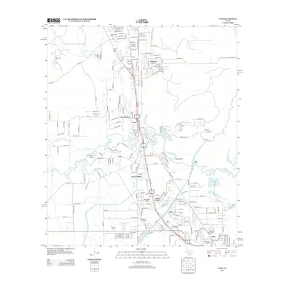
2013 Map of Voth
USGS Topo · Published 2013About this map
Pine Island Bayou and its winding tributaries, including Black Cr and Walker Br, define the landscape of northern Beaumont. This area shows a transition from the industrial Ariola Oil Field and the Ariola Lookout Tower in the north to established residential communities further south. The map documents the layout of neighborhood clusters like Voth, Loeb, and Bor-ley Heights, which are linked by a dense network of local roads and major thoroughfares. The presence of the Lower Neches Valley Authority Canal and the B I Canal highlights the significance of water management and irrigation in this part of Jefferson County. Genealogists will find the locations of Loeb Cem and Spell Cem particularly useful for tracing local family histories near the settlements of Rosedale and Helbig.
Find a feature on this map
212 named features on this map. Tap any name to fly to it.
Don’t see what you’re looking for? This feature index may not catch every label — zoom into the map to look around manually.
Map Details
Editions of this 2013 Voth Map
This is the sole edition of this map. No revisions or reprints were ever made.
Other maps of this area

1926 · Lakeview
USGS Topo · 1:24,000

1926 · Vidor
USGS Topo · 1:24,000

1932 · Beaumont
USGS Topo · 1:62,500

1943 · Beaumont East
USGS Topo · 1:24,000

1954 · Beaumont
USGS Topo · 1:250,000

1955 · Silsbee
USGS Topo · 1:62,500

1955 · Kountze
USGS Topo · 1:62,500

1955 · Sour Lake
USGS Topo · 1:62,500

1957 · Beaumont
USGS Topo · 1:250,000
1960 · Beaumont West
USGS Topo · 1:24,000