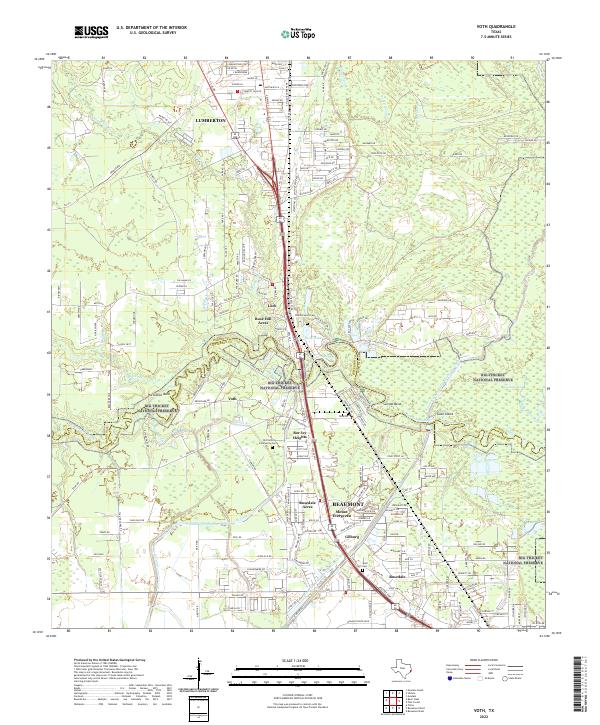
2022 Map of Voth
USGS Topo · Published 2022About this map
Big Thicket National Preserve anchors this landscape, following the winding course of the Pine Island Bayou as it separates Hardin and Jefferson Counties. The area showcases a transition from the established northern neighborhoods of Beaumont, such as Rosedale Acres and Mount Evergreen, toward the developing residential pockets of Lumberton. Water management is a defining characteristic of the terrain, visible through the extensive Lower Neches Valley Authority Canal system and smaller channels like the B1 Canal. Local history is preserved in several small burial grounds, including the Old Voth Community Cem and Leatherwood Cem, which sit near the small communities of Voth and Loeb. The map also captures the distinct hydrology of the bayou, featuring sharp meanders such as Horseshoe Bend and Suicide Bend, alongside named landforms like Goat Island.
Find a feature on this map
189 named features on this map. Tap any name to fly to it.
Don’t see what you’re looking for? This feature index may not catch every label — zoom into the map to look around manually.
Map Details
Editions of this 2022 Voth Map
This is the sole edition of this map. No revisions or reprints were ever made.
Other maps of this area

1926 · Lakeview
USGS Topo · 1:24,000

1926 · Vidor
USGS Topo · 1:24,000

1932 · Beaumont
USGS Topo · 1:62,500

1943 · Beaumont East
USGS Topo · 1:24,000

1954 · Beaumont
USGS Topo · 1:250,000

1955 · Silsbee
USGS Topo · 1:62,500

1955 · Kountze
USGS Topo · 1:62,500

1955 · Sour Lake
USGS Topo · 1:62,500

1957 · Beaumont
USGS Topo · 1:250,000
1960 · Beaumont West
USGS Topo · 1:24,000