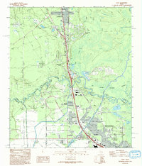
1993 Map of Voth
USGS Topo · Published 1993About this map
The Big Thicket National Preserve dominates the center of this landscape, where the Neches River meanders through a complex network of waterways like Village Slough and Boggy Creek. This early 1990s record captures the suburban expansion between Lumberton and the northern reaches of Beaumont, showcasing established residential clusters such as Woodcrest Acres and Rose Hill Acres. The presence of the Arriola Oil Field and various pipelines indicates the persistent industrial influence of the energy sector on the local economy.
Find a feature on this map
52 named features on this map. Tap any name to fly to it.
Don’t see what you’re looking for? This feature index may not catch every label — zoom into the map to look around manually.
Map Details
Editions of this 1993 Voth Map
This is the sole edition of this map. No revisions or reprints were ever made.
Other maps of this area

1926 · Lakeview
USGS Topo · 1:24,000

1926 · Vidor
USGS Topo · 1:24,000

1932 · Beaumont
USGS Topo · 1:62,500

1943 · Beaumont East
USGS Topo · 1:24,000

1954 · Beaumont
USGS Topo · 1:250,000

1955 · Silsbee
USGS Topo · 1:62,500

1955 · Kountze
USGS Topo · 1:62,500

1955 · Sour Lake
USGS Topo · 1:62,500

1957 · Beaumont
USGS Topo · 1:250,000
1960 · Beaumont West
USGS Topo · 1:24,000