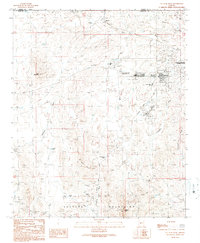
1990 Map of Vulture Peak
USGS Topo · Published 1990About this map
Wickenburg and the surrounding high desert terrain are defined by a legacy of mining and transit in this 1990 provisional study. The landscape is dotted with numerous Prospects and named operations like the Renegade Mine, Lucky Day Mine, and Big Spar Mine, illustrating the persistent mineral interests within the Vulture Mountains. Near the Municipal Airport, the Wickenburg Massacre Historical Monument marks a specific point of local historical gravity. Transport infrastructure is anchored by the Atchison Topeka and Santa Fe railroad, which passes through the settlement of Matthie in the north. The presence of the Vulture Peak Sch and a local Cemetery suggests a community growing alongside these industrial and ranching roots, while numerous tanks such as Pouquette Tank point to the necessity of water management in this arid environment.
Find a feature on this map
35 named features on this map. Tap any name to fly to it.
Don’t see what you’re looking for? This feature index may not catch every label — zoom into the map to look around manually.
Map Details
Editions of this 1990 Vulture Peak Map
2 editions found
Other maps of this area

1887 · Prescott
USGS Topo · 1:250,000

1892 · Prescott
USGS Topo · 1:250,000

1903 · Congress
USGS Topo · 1:125,000

1904 · Congress
USGS Topo · 1:125,000

1947 · Wagoner
USGS Topo · 1:62,500

1948 · Wagoner
USGS Topo · 1:63,360

1950 · Wagoner
USGS Topo · 1:62,500

1950 · Prescott
USGS Topo · 1:250,000

1954 · Prescott
USGS Topo · 1:250,000

1954 · Phoenix
USGS Topo · 1:250,000