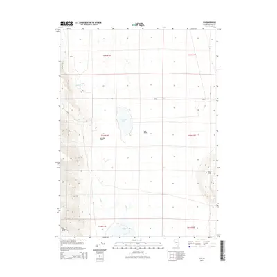
2015 Map of Vya
USGS Topo · Published 2015About this map
Long Valley anchors this high-desert landscape in northwestern Washoe County, where the isolated settlement of Vya serves as a remote crossroads for CR-34 and CR-8a. The terrain transitions from the alluvial floor of the valley toward the prominent heights of the Hays Canyon Range to the southwest and the Black Hills in the southeast. Water is a defining but ephemeral feature of this arid region, characterized by seasonal drainages like Secret Cr and South Cr, which feed into basins such as Fortynine Lake and Central Lake. The map reveals a land structured by the Public Land Survey System and ranching-era infrastructure, where reliable water sources like Twin Springs were vital for survival and livestock. The deep incisions of North Bar Canyon provide a stark contrast to the broad flats, illustrating the geological character of the Nevada high desert during the early twenty-first century.
Find a feature on this map
19 named features on this map. Tap any name to fly to it.
Don’t see what you’re looking for? This feature index may not catch every label — zoom into the map to look around manually.
Map Details
Editions of this 2015 Vya Map
This is the sole edition of this map. No revisions or reprints were ever made.
Other maps of this area

1889 · Long Valley
USGS Topo · 1:250,000

1954 · Vya
USGS Topo · 1:250,000

1958 · Vya
USGS Topo · 1:250,000

1962 · Vya
USGS Topo · 1:250,000

1966 · Massacre Lake NW
USGS Topo · 1:24,000

1966 · Vya
USGS Topo · 1:24,000
1966 · Carter Reservoir
USGS Topo · 1:24,000

1966 · Alkali Lake
USGS Topo · 1:24,000

1966 · Painted Point
USGS Topo · 1:24,000
1966 · Fortynine Mtn.
USGS Topo · 1:24,000