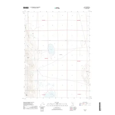
2018 Map of Vya
USGS Topo · Published 2018About this map
Vya serves as the primary landmark in this remote corner of northwest Nevada, situated at the intersection of C R 34 and Co Rte 8a. The landscape is dominated by the wide expanse of Long Valley, which is punctuated by seasonal hydrologic features like Fortynine Lake and Central Lake. The high-desert terrain is defined by the steep rises of the Hays Canyon Range in the southwest and the Black Hills to the east, illustrating a classic Great Basin basin-and-range topography. Small water sources such as Twin Springs and the intermittent flows of Secret Cr and S Cr suggest the vital role of water management in this arid cattle-country environment. The network of secondary roads, including Dugway RD, highlights the connectivity required for ranching and resource management across these expansive townships.
Find a feature on this map
19 named features on this map. Tap any name to fly to it.
Don’t see what you’re looking for? This feature index may not catch every label — zoom into the map to look around manually.
Map Details
Editions of this 2018 Vya Map
This is the sole edition of this map. No revisions or reprints were ever made.
Other maps of this area

1889 · Long Valley
USGS Topo · 1:250,000

1954 · Vya
USGS Topo · 1:250,000

1958 · Vya
USGS Topo · 1:250,000

1962 · Vya
USGS Topo · 1:250,000

1966 · Massacre Lake NW
USGS Topo · 1:24,000

1966 · Vya
USGS Topo · 1:24,000
1966 · Carter Reservoir
USGS Topo · 1:24,000

1966 · Alkali Lake
USGS Topo · 1:24,000

1966 · Painted Point
USGS Topo · 1:24,000
1966 · Fortynine Mtn.
USGS Topo · 1:24,000