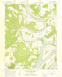
1958 Map of Wabash Island
USGS Topo · Published 1959About this map
The Wabash River meanders toward its confluence with the Ohio River in this late 1950s survey, a landscape defined by shifting watercourses and dense bottomlands. The tri-state boundary between Indiana, Illinois, and Kentucky meets near the expansive Wabash Island, where the river's path is marked by historical landmarks like the Bone Bank and Mackeys Island. On the Illinois side, the Shawneetown Hills rise above the alluvial plain, providing a natural vantage point for a Lookout Tower overlooking the river valley.
Find a feature on this map
38 named features on this map. Tap any name to fly to it.
Don’t see what you’re looking for? This feature index may not catch every label — zoom into the map to look around manually.
Map Details
Editions of this 1958 Wabash Island Map
2 editions found
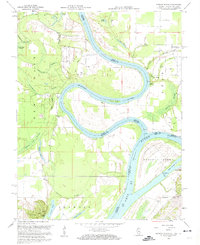
Other maps of this area

1905 · New Haven
USGS Topo · 1:62,500

1906 · New Haven
USGS Topo · 1:62,500

1907 · Morganfield
USGS Topo · 1:62,500

1916 · Shawneetown
USGS Topo · 1:62,500

1917 · Uniontown
USGS Topo · 1:62,500

1949 · Paducah
USGS Topo · 1:250,000

1949 · New Haven
USGS Topo · 1:62,500

1949 · Morganfield
USGS Topo · 1:24,000

1950 · Paducah
USGS Topo · 1:250,000
1951 · Morganfield
USGS Topo · 1:24,000