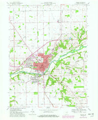
1963 Map of Wabash
USGS Topo · Published 1982About this map
The Wabash River carves a deep valley through this north-central Indiana landscape, anchoring the city of Wabash as it appeared in the early 1960s with updates through 1981. The town's grid is dense with civic landmarks, including the central Courthouse, City Hall, and the Century School. Along the riverbanks, topographic features like Potter Island and the drainage of Charley Creek contrast with the industrial and transportation corridors defined by the Conrail and Norfolk and Western railroads. Beyond the urban center, the map documents a sprawling network of rural cemeteries like Falls Cemetery and Hebrew Cemetery, alongside outlying developments such as Sunnymede and South Haven. The surrounding townships of Noble and Lagro are marked by significant landmarks including the Wabash Municipal Airport and Northfield High School, illustrating the region's mid-century transition toward expanded infrastructure and suburban residential growth.
Find a feature on this map
73 named features on this map. Tap any name to fly to it.
Don’t see what you’re looking for? This feature index may not catch every label — zoom into the map to look around manually.
Map Details
Editions of this 1963 Wabash Map
Other maps of this area

1950 · Lagro
USGS Topo · 1:24,000

1951 · Lagro
USGS Topo · 1:24,000

1951 · Richvalley
USGS Topo · 1:24,000

1952 · Wabash
USGS Topo · 1:24,000

1953 · La Fontaine
USGS Topo · 1:24,000

1953 · Somerset
USGS Topo · 1:24,000

1953 · Peoria
USGS Topo · 1:24,000

1953 · Muncie
USGS Topo · 1:250,000

1956 · Muncie
USGS Topo · 1:250,000

1961 · Roann
USGS Topo · 1:24,000