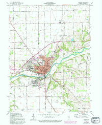
1963 Map of Wabash
USGS Topo · Published 1994About this map
The Wabash River carves a deep valley through this landscape, anchoring the city of Wabash as it appeared in the mid-20th century. The town center is densely structured with civic landmarks like the Courthouse, City Hall, and several historical schools including Century Sch and Eastwood Sch. Beyond the residential neighborhoods of Sunnymede and Valley Brook, the land transitions into a productive agricultural and industrial corridor served by the Conrail line.
Find a feature on this map
93 named features on this map. Tap any name to fly to it.
Don’t see what you’re looking for? This feature index may not catch every label — zoom into the map to look around manually.
Map Details
Editions of this 1963 Wabash Map
Other maps of this area

1950 · Lagro
USGS Topo · 1:24,000

1951 · Lagro
USGS Topo · 1:24,000

1951 · Richvalley
USGS Topo · 1:24,000

1952 · Wabash
USGS Topo · 1:24,000

1953 · La Fontaine
USGS Topo · 1:24,000

1953 · Somerset
USGS Topo · 1:24,000

1953 · Peoria
USGS Topo · 1:24,000

1953 · Muncie
USGS Topo · 1:250,000

1956 · Muncie
USGS Topo · 1:250,000

1961 · Roann
USGS Topo · 1:24,000