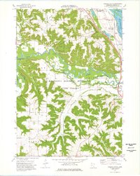
1974 Map of Wabasha South
USGS Topo · Published 1976About this map
Wabasha and the Mississippi River valley dominate the northeastern corner of this mid-1970s topographical record. The terrain is defined by dramatic elevation changes at Coffee Mill Bluff and Greenfield Hill, overlooking the Chicago Milwaukee St Paul and Pacific railroad line that follows the river's edge. The Zumbro River snakes through the center of the sheet, feeding into complex wetlands such as Albertson Slough and Fry Slough.
Find a feature on this map
52 named features on this map. Tap any name to fly to it.
Don’t see what you’re looking for? This feature index may not catch every label — zoom into the map to look around manually.
Map Details
Editions of this 1974 Wabasha South Map
This is the sole edition of this map. No revisions or reprints were ever made.
Other maps of this area

1932 · Cochrane
USGS Topo · 1:62,500

1932 · Wabasha
USGS Topo · 1:62,500

1932 · Alma
USGS Topo · 1:62,500

1934 · Plainview
USGS Topo · 1:62,500

1934 · Cochrane
USGS Topo · 1:62,500

1937 · Cochrane
USGS Topo · 1:62,500

1938 · Plainview
USGS Topo · 1:62,500

1950 · Alma
USGS Topo · 1:62,500

1951 · Wabasha
USGS Topo · 1:62,500

1953 · Saint Paul
USGS Topo · 1:250,000