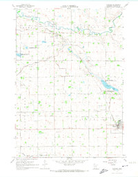
1967 Map of Wabasso
USGS Topo · Published 1974About this map
The Chicago and North Western railway lines anchor this corner of Redwood County, connecting the grain-growing prairies of Vail and Granite Rock townships. The local economy is defined by the proximity of the Redwood River and a sophisticated network of water management features, including Judicial Ditch No 100 and County Ditch No 90. These drainage systems transformed the landscape for agricultural use, while areas like the Daubs Lake State Wildlife Management Area and Rohlik State Wildlife Management Area preserved pockets of the original wetland environment.
Find a feature on this map
27 named features on this map. Tap any name to fly to it.
Don’t see what you’re looking for? This feature index may not catch every label — zoom into the map to look around manually.
Map Details
Editions of this 1967 Wabasso Map
2 editions found
Other maps of this area

1952 · Redwood Falls
USGS Topo · 1:62,500

1953 · New Ulm
USGS Topo · 1:250,000

1957 · New Ulm
USGS Topo · 1:250,000

1958 · New Ulm
USGS Topo · 1:250,000

1965 · Echo
USGS Topo · 1:24,000

1965 · Belview
USGS Topo · 1:24,000

1967 · New Ulm
USGS Topo · 1:250,000

1967 · Wanda
USGS Topo · 1:24,000

1967 · Wabasso SE
USGS Topo · 1:24,000

1967 · Wabasso
USGS Topo · 1:24,000