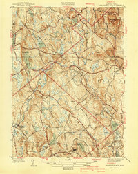
1940 Map of Wachusett Mtn
USGS Topo · Published 1940About this map
Wachusett Mountain State Reservation dominates the northeastern landscape of this Worcester County survey, where the peak of Wachusett Mountain looks over a network of early 20th-century institutions and infrastructure. The map documents significant medical and public works facilities, including the Central New England Sanatorium and the State Sanitorium near Rutland. A notable subterranean feature, the Quabbin Aqueduct, passes beneath the hills, highlighting the region's role in the regional water supply. Settlement patterns are defined by rail connections like the Boston and Maine Railroad, serving small hubs such as Princeton Sta and Hubbardston Sta. Numerous local burial grounds, such as Woodlawn Cem and Rural Glen Cem, provide valuable landmarks for genealogists tracking family histories in the townships of Princeton and Hubbardston before mid-century modern expansion.
Find a feature on this map
58 named features on this map. Tap any name to fly to it.
Don’t see what you’re looking for? This feature index may not catch every label — zoom into the map to look around manually.
Map Details
Editions of this 1940 Wachusett Mtn Map
2 editions found
Other maps of this area

1885 · Worcester
USGS Topo · 1:62,500

1886 · Worcester
USGS Topo · 1:62,500

1887 · Winchendon
USGS Topo · 1:62,500

1887 · Barre
USGS Topo · 1:62,500

1887 · Fitchburg
USGS Topo · 1:62,500

1889 · Fitchburg
USGS Topo · 1:62,500

1889 · Barre
USGS Topo · 1:62,500

1890 · Winchendon
USGS Topo · 1:62,500

1892 · Worcester
USGS Topo · 1:62,500

1893 · Fitchburg
USGS Topo · 1:62,500