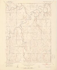
1953 Map of Waconda Springs
USGS Topo · Published 1954About this map
Waconda Springs and the Great Spirit Spring are the central landmarks of this Mitchell County landscape, situated near the confluence of the North Fork and South Fork of the Solomon River. The terrain is characterized by the winding river valleys and the creek systems of Carr Creek, Oak Creek, and Mill Creek that drain the surrounding uplands. Published as part of a Missouri River Basin development program, the map documents the rural infrastructure of the early 1950s, including the Missouri Pacific railroad line following the river's northern bank.
Find a feature on this map
23 named features on this map. Tap any name to fly to it.
Don’t see what you’re looking for? This feature index may not catch every label — zoom into the map to look around manually.
Map Details
Editions of this 1953 Waconda Springs Map
4 editions found
Other maps of this area

1893 · Smith Center
USGS Topo · 1:125,000

1894 · Mankato
USGS Topo · 1:125,000

1894 · Beloit
USGS Topo · 1:125,000

1896 · Osborne
USGS Topo · 1:125,000

1953 · Downs South
USGS Topo · 1:24,000

1953 · Waconda Springs
USGS Topo · 1:24,000

1953 · Glen Elder South
USGS Topo · 1:24,000

1955 · Beloit
USGS Topo · 1:250,000

1959 · Beloit
USGS Topo · 1:250,000

1960 · Downs North
USGS Topo · 1:24,000