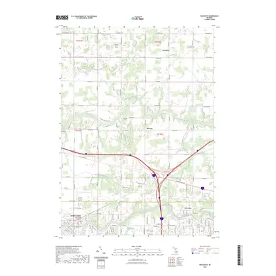
2023 Map of Wacousta
USGS Topo · Published 2023About this map
The Looking Glass River and the Grand River dictate the development of this landscape along the border of Clinton County and Eaton County. The northern portion of the map is defined by unincorporated communities and crossroads like Wacousta and South Riley, where local history is anchored by the Wacousta Cem and South Riley Cem. These areas maintain a distinct agricultural character, marked by an extensive network of drainage features such as the Westphalia and Riley Drain and the Tibbetts Drain.
Find a feature on this map
64 named features on this map. Tap any name to fly to it.
Don’t see what you’re looking for? This feature index may not catch every label — zoom into the map to look around manually.
Map Details
Editions of this 2023 Wacousta Map
This is the sole edition of this map. No revisions or reprints were ever made.
Other maps of this area

1910 · Lansing
USGS Topo · 1:62,500

1912 · Lansing
USGS Topo · 1:62,500

1927 · De Witt
USGS Topo · 1:62,500

1945 · Portland
USGS Topo · 1:62,500

1949 · Charlotte
USGS Topo · 1:62,500

1958 · Grand Rapids
USGS Topo · 1:250,000

1961 · Grand Rapids
USGS Topo · 1:250,000

1962 · Grand Rapids
USGS Topo · 1:250,000
1965 · St. Johns South
USGS Topo · 1:24,000
1965 · Lansing South
USGS Topo · 1:24,000
Featured Places
- Grand Ledge, MI
- Watertown Charter Township, MI
- Westphalia Township, MI
- Eagle Township, MI
- Delta Charter Township, MI