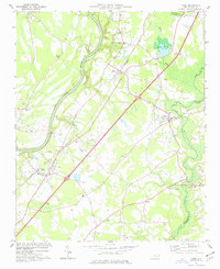
1974 Map of Wade
USGS Topo · Published 1977About this map
The Cape Fear River and South River define the agricultural and swampy landscape of northern Cumberland County in the mid-1970s. This corridor is anchored by the small settlements of Wade, Godwin, Falcon, and Cooper, situated along the critical transit lines of the Seaboard Coast Line and a major 4 Lane highway. The map provides a detailed look at rural communal life through its numerous churches, including Colliers Chapel, Elizabeth Ch, and Wesley Chapel. A significant historical marker is found in the northern section with the Averasboro Battleground Monument, indicating the area's role in Civil War history. The presence of several sandpits near Cooper and Rhodes Pond suggests local extractive industry, while various small cemeteries and schools like the Culbreth Memorial highlight the long-standing family and social foundations of these North Carolina communities.
Find a feature on this map
40 named features on this map. Tap any name to fly to it.
Don’t see what you’re looking for? This feature index may not catch every label — zoom into the map to look around manually.
Map Details
Editions of this 1974 Wade Map
2 editions found
Other maps of this area

1948 · Fayetteville
USGS Topo · 1:62,500

1948 · Slocomb
USGS Topo · 1:24,000

1949 · Vander
USGS Topo · 1:24,000

1950 · Slocomb
USGS Topo · 1:24,000

1953 · Raleigh
USGS Topo · 1:250,000

1954 · Raleigh
USGS Topo · 1:250,000

1956 · Bunnlevel
USGS Topo · 1:24,000

1957 · Vander
USGS Topo · 1:24,000

1957 · Fayetteville
USGS Topo · 1:62,500

1973 · Dunn
USGS Topo · 1:24,000