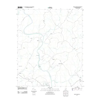
2011 Map of Wadley North
USGS Topo · Published 2011About this map
The Tallapoosa River carves a winding path through the heart of this Randolph County landscape, creating prominent features like Hodge Island and Price Island. Small rural settlements such as Malone, Corinth, and Almond anchor the community, while the presence of numerous family and church burial grounds, including Gay Cemetery, Knight Cemetery, and Antioch Cemetery, provides a wealth of data for local historians. The southern edge of the sheet is marked by the institutional presence of College Lake and the Wadley Cemetery, just north of the town center. Local infrastructure is evidenced by the Knight Dam and Frost Dam, which manage the area's many tributaries like No Business Creek and Cornhouse Creek. This survey details a terrain defined by its watercourses and small-scale agriculture at the start of the 2010s.
Find a feature on this map
80 named features on this map. Tap any name to fly to it.
Don’t see what you’re looking for? This feature index may not catch every label — zoom into the map to look around manually.
Map Details
Editions of this 2011 Wadley North Map
This is the sole edition of this map. No revisions or reprints were ever made.
Other maps of this area

1891 · Ashland
USGS Topo · 1:125,000

1899 · Wedowee
USGS Topo · 1:125,000

1902 · Wedowee
USGS Topo · 1:125,000

1953 · Atlanta
USGS Topo · 1:250,000

1957 · Atlanta
USGS Topo · 1:250,000

1958 · Atlanta
USGS Topo · 1:250,000

1969 · Wadley North
USGS Topo · 1:24,000
1969 · Wedowee
USGS Topo · 1:24,000
1969 · Daviston
USGS Topo · 1:24,000
1969 · Wadley South
USGS Topo · 1:24,000